[@ModernRogue] Google Maps, But It Avoids Surveillance Cameras
· 5 min read
Link: https://youtu.be/8LrlbEDJNU4
Duration: 12 min
Transcript: Download plain text
Short Summary
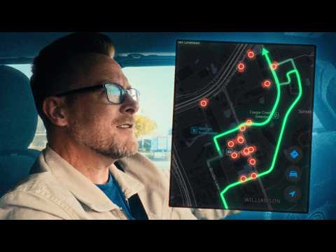
The hosts field-test the Flock Hopper navigation app in Austin at the request of Ninja Geek, running a three-leg route from Dog's Backyard Grill to Docks Backyard to the Pint House. Guest Jordan Breeding explains that the app routes around Flock Safety cameras by flagging how many are ahead, offering a privacy mode, and issuing counterintuitive instructions like "turn left to go right." The verdict: it works, is not too painful to use, and functions in Austin, though one camera they bypassed was removed within two weeks and the app makes drivers hyper-aware rather than invisible.
Key Quotes
- "The first leg, we encountered some minor deviations to bypass some of the Flock cameras. We bypassed three Flock cameras for that. A little inconvenient, but not that big of a deal." (00:08:38)
- "In my mind, I was wondering, oh my god, does this app make you invisible to Flock cameras? Like, if they don't see you, you don't exist. [music] And the answer is no, it does not. But, it does something even better." (00:09:23)
- "It was maybe a little loose with the time estimates. The direct path it estimated was 17 [music] minutes. The most private path it estimated was 21 minutes. Google Maps in off-peak hours, where there's basically no traffic, it says 24 minutes. And that's direct. Our trip took 32 minutes." (00:11:00)
- "So, they just the whole bust is is gone because because cops can't be bothered to know how to use it constitutionally." (00:06:09)
- "There's a little bit of that kind of nudge between automatic opt-in versus automatic opt-out. If you tell yourself, "I'm going to check deflacted.org," then you're automatically opting in to being seen, [music] and you have to get out of that gravity well to take action to know what you're going to see. Whereas, if you default to using this app, you are defaulting to opting out of getting [music] seen, and then you have to make the conscious decision, "I'm going to ignore the fact that there's a flag camera there."" (00:10:22)
Detailed Summary
Overview
- The episode is a field test of the Flock Hopper navigation app in Austin, conducted at the request of Ninja Geek, with three questions driving the test: does Flock Hopper work, is it too painful to use, and does it function in Austin.
- Guest Jordan Breeding frames the drive as a single trip with three legs, each representing a different scenario people might encounter with Flock Safety cameras.
How the App Works
- Flock Hopper requires the user's location and routes around Flock cameras by showing the fastest route and flagging how many cameras are on the way, such as three cameras flagged on one route.
- The app also offers a privacy mode that produces a more private (slower) path rather than simply the fastest one.
- Guidance can be counterintuitive: instructions like "turn left to go right" and a route warning reading "Get out. Get out while you still can. They're everywhere," on a fastest path of 2.3 miles.
The Three-Leg Test Route
- The route ran from Dog's Backyard Grill on Brodie to Docks Backyard, the site of a Meshtastic meetup, and then to the Pint House.
- Leg one required minor deviations to bypass three Flock cameras, which the testers described as only a minor inconvenience.
- Leg two required one major detour, revealing a real cost to camera avoidance; they attributed it to Austin being fairly rural and their position on the perimeter rather than downtown.
- Leg three showed no difference in Flock camera exposure between the two paths.
Where the App Beat the Map
- At the Pint House the app showed zero cameras, even though the printed map indicated cameras nearby near P. Terry's.
- The reason was that those cameras are visually obscured, so the app's guidance was more accurate than reading the map in that spot.
Timing Numbers
- The app estimated 17 minutes for the direct path and 21 minutes for the most private path.
- Google Maps off-peak estimated 24 minutes direct, and the actual trip took 32 minutes.
Surprises and Caveats
- One of the Flock cameras they drove past had been recorded less than two weeks earlier and no longer existed, with no indication of whether it was lawfully removed.
- The app does not make a driver invisible to Flock cameras; its benefit is that it continuously informs the user along the route, making drivers hyper-aware when the app says to turn or go around.
- There is an opt-in/opt-out nudge built into the design: visiting deflacted.org automatically opts the user in to being seen, while defaulting to using the app opts them out, requiring a conscious decision to ignore a camera warning.
- They noted there is no place to post comments on deflacted.org.
Recommendation
- Jordan Breeding advised being hesitant about using the Flock Hopper app if you must be somewhere at a very specific time, but said it otherwise seemed to work.
- The team had good expectations for Austin but wanted to know whether the app would be useless or useful in other cities.
Context
- 404 Media released body camera footage of an officer standing next to a suspect and using Flock camera travel history to make an unconstitutional search; roughly 100 kilos of meth were found, but the search was ruled unconstitutional and the bust was thrown out.